Building a Web-Based Spatial DSS for Environmental Planning and Management
by Ramanathan Sugumaran and Jim Meyer
Problem Statement and Background
Many of the major problems faced by local governments involve issues associated with urbanization. The increased rate of urbanization has led to haphazard growth, increased infrastructure costs, deterioration of living conditions and worsening of the environment. This phenomenon places a heavy burden on local planners and managers, who struggle to balance competing demands for residential, commercial, and industrial development with imperatives to minimize environmental degradation. In order to effectively manage this development process on a sustainable basis, local government planners increasingly rely on the use of information technologies, spatial modeling techniques (Dragicevic et al., 2000) and Spatial Decision Support Systems (SDSS) (Fedra, 1995, Sugumaran et al., 2000). These technologies and techniques include combinations of remote sensing, GIS, spatial modeling, and Internet technology. Although lately there has been significant progress in the use of the Web as a medium for environmental data sharing and data visualization (Dragicevic et al., 2000; Houle et al., 200; Sugumaran et al,. 2002), few studies have focused on developing a Web-based Spatial Decision Support System (SDSS) for environmental planning and management. The present study develops a Web-Based Spatial Decision Support System (WEBSDSS) prototype to prioritize local watersheds on the basis of environmental sensitivity using a multiple criteria evaluation model for the City of Columbia, Missouri. The Internet was chosen as a development platform in this study mainly because of its openness and interactivity, which allow public access to and participation in the analysis (Dragicevic et al., 2000; Sugumaran et al., 2000).
Design and Development of WEBSDSS
The development of the WEBSDSS involves three stages, the first stage was to establish the relevant environmental criteria at watershed level with local officials, the next step was the collection and development of different spatial and non-spatial data layers to address each criterion and finally the development of Web-Based Spatial Decision Support System to allow public interaction and analysis. Each step is described below and also screen shots are included.
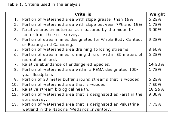
Collection of Environmental CriteriaFor the pilot project, a local advisory committee (mainly storm water planning team members) selected twelve environmental criteria to use in thirteen local watersheds comprising an area of about 84,000 acres. These criteria were selected based on the issues that were of most concern to local decision makers and stakeholders. They were chosen to address public health, surface water and groundwater quality concerns. Multi-Criteria Evaluation using weighted linear combination was adopted for this study. In order to collect weights for each criterion, the advisory committee assigned weights to each according to their importance relative to one another. The criteria and weights chosen are given in Table 1. In addition to these twelve criteria, the advisory committee was very interested in the proportion of each watershed covered by impervious surfaces which was developed from high resolution satellite images called IKONOS.
Collection of GIS Source and other Datasets at watershed level
In the second stage of the project, relevant GIS layers were developed from a variety of sources including remotely sensed imagery, digital soils surveys, the National Elevation Dataset and field sampling.
Design and Development of WEBSDSSThe WEBSDSS design is based on the client/server model in which clients send requests to services running on a server and receive appropriate information in response (Figure 1). A client-server architecture was used because it facilitates maintenance of the application and its data layers. In addition, the functionality of the application can be upgraded or replaced at any time without affecting the user’s computer system. The client/server used in this study has a three-tiered configuration consisting of: Tier 1 a WWW client, Microsoft Internet Explorer (IE) or Netscape Navigator; Tier 2 a WWW server, Microsoft Internet Information Server (IIS); and Tier 3 a WWW-based GIS server, ArcView Internet Map Server (AvIMS). This application utilized a Java applet-based AvIMS developed by ESRI. A Java-based programming environment was chosen because it is object-oriented and supports the development of portable, interpreted, system-independent, and distributed applications served on the WWW. The Java functionality used here is integral to the Web browser’s Java Virtual Machine and does not require the user to install any additional components. This is particularly helpful to users in large organizations and government institutions, who often do not possess user access permissions to install software or Web browser plug-ins on their own workstations.

WEBSDSS in Action
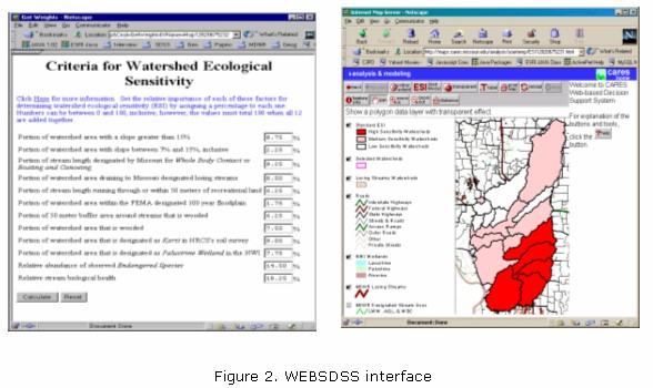
The WEBSDSS homepage is available to the general public at http://maps.cares.missouri.edu/analysis/esi/. The homepage explains the goals and describes the project. Clicking the start icon located at the top of the homepage starts WEBSDSS. Figure 2 shows the simple interfaces developed for the end user. The help button (right side frame) provides a description of each button.
Upon entering the interactive page, the user can display the data layers and also perform analysis. WEBSDSS uses standard image/GIS data browsing tools built into MapCafé to allow users to interact with the map display (Figure 2). In addition, WEBSDSS also provides customized buttons to start the ESI model, adjust the transparency of the GIS layers, label map features, and print maps. These functions operate on the map display and the information window to provide the user interface to the model, including the display and report capability.
The “start ESI model” button in WEBSDSS interface allows the user to perform the analysis with their set of criteria weights. When this button is pressed, a new window opens to provide the user with the list of criteria and to accept weight values input by the user. The default values displayed initially are the weights set by the storm water steering committee (Table 1). Interested parties may access the underlying data and conduct their own analyses using their own assessments of the relative importance of the environmental criteria.
Conclusions and Future Directions
This Web-based Spatial Decision Support System provides users a simple decision support tool to identify and prioritize local watersheds based on several environmental criteria. The present prototype of WEBSDSS was developed using only a few watersheds in the county as test sites and has limited environmental criteria. County and city officials want this tool expanded for the entire county and want to include more criteria in it. Future work will enhance the WEBSDSS by collecting better and/or improved data sets and an assessment will be prepared for the entire county. Also, additional relevant criteria will be solicited from the public and included in future analyses.
Questions for Analysis and Discussion
- Is WEBSDSS a DSS?
- What decision support technologies are used?
- Is this system a data-driven spatial DSS? or Is it a model-driven DSS with spatial representations?
- What is the purpose of the multi-criteria model?
- How is WEBSDSS used? Who are the target users?
- What is the benefit of having a specific DSS for environmental planning and management?
- Why was this DSS implemented using Web technologies?
- Do you anticipate any problems with the system? If so, explain them.
References
Dragicevic, S., Balram, S., Lewis, J., 2000, The role of Web GIS tools in the environmental modeling and decision-making process. 4th International Conference on Integrating GIS and Environmental Modeling (GIS/EM4): Problems, Prospects and Research Needs. Banff, Alberta, Canada, September 2 - 8, 2000.
Fedra, K., 1995. Decision Support for Natural Resources Management: Models, GIS and Expert Systems. AI Applications, 9, 3-19.
Houle, M., Dragicevic, S., and Boudreault, F., 2000, A Web-based GIS tool for accessing spatial environmental data on the St. Lawrence River. Proceeding of 4th International Conference on Integrating GIS and Environmental Modeling (GIS/EM4): Problems, Prospects and Research Needs. Banff, Alberta, Canada, September 2 - 8, 2000.
Sugumaran, R., Davis, C.H., Meyer, J., Prato, T., and Fulcher, C., 2000, Web- Based Decision Support Tool for Floodplain Management using High Resolution DEM. Journal of Photogrammetric Engineering and Remote Sensing (PE&RS), 66, 1261-1265.
Sugumaran, R., 2002. Development of a Range Management Decision Support System using Remote Sensing, GIS and Knowledge Based System. Computers and Electronics in Agriculture, Vol. 37: pp. 199-205.
About the Authors
Ramanathan Sugumaran is an Assistant Professor of Geography at the University of Northern Iowa and an affiliated faculty member in the Center for Agricultural, Resource and Environmental Systems at the University of Missouri-Columbia.
Jim Meyer is a Geographic Information Systems Specialist at the Center for Agricultural, Resource and Environmental Systems (CARES) at the University of Missouri-Columbia.
Please cite as:
Sugumaran, R. and J. Meyer, "Building a Web-Based Spatial Decision Support System (WEBSDSS) for Environmental Planning and Management", 2003, at URL DSSResources.COM.
Ramanathan Sugumaran provided final permission to use this case study on May 19, 2003. Sugumaran's email address is Ramanathan.Sugumaran@uni.edu. This case study was posted at DSSResources.COM on June 14, 2003.
This case study is provided for informational purposes only. DSSResources.COM makes no warranties, express or implied, about this case summary.